Hey Alexa, Where is FAO Working in Uganda?
This week, we’re highlighting the release of the Autogeocoder tool. This post is the first of a two-part blog series on the tool, so stay tuned for the next post later this week.
We Started With a Question
Okay, so we might not be able to ask our smart home systems questions about where development efforts are taking place just yet. However, during last year’s London Tech Accelerator Workshop, we worked to determine whether we could use Machine Learning to help us more quickly answer that very question, “Where is FAO working in Uganda?”
As part of the Initiative for Open Ag Funding, we know that this type of question is not only asked regularly by agriculture practitioners, but also that they want quick answers. However, if organizations don’t have an already-existing internal process for gathering and reporting sub-national location information, answering these questions typically means spending months of manual effort to collect this information, sometimes reading through huge amounts of project documents to find where exactly project activities are taking place.
And how does the AutoGeocoder fit in?
DG has now released a suite of open source AutoGeocoding tools that use Natural Language Processing and Machine Learning to read through project documents and text for location information, then identifying where project activities are taking place. The tool runs the location names it finds through the Geonames geographical database to supplement the location name with other information typically useful to understand the activity’s location. For example, this supplementary information might include the location’s administrative level, its latitude and longitude coordinates, feature designation, etc.
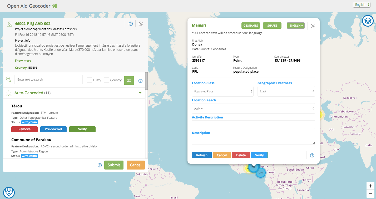
Figure 1: the OpenAid Geocoder 2.0 Dashboard
Features of the AutoGeocoder
The AutoGeocoder has been integrated into the Open Aid Geocoder 2.0, which allows users to import valid IATI XML files, run them through the Autogeocoder if desired, and then validate location suggestions made by the AutoGeocoder. (A note for IATI gurus: the tool is configured to find and search through documents tagged as types A02 and A07). Users can even search for and add locations that the AutoGeocoder might not have caught on its own (after all, this first version of the AutoGeocoder is definitely not perfect). You can check out our demo site here and the User Guide here.
The Open Aid Geocoder is built in modules, so its various pieces – such as just the AutoGeocoder itself, and/or the Map User Interface – can be used and integrated into various systems, including into an organization’s own Information Management System (IMS).
The AutoGeocoder was also integrated into a very basic interface, which we used to test its performance and output. While not initially intended for public use, we feel this interface may be useful as it allows anyone to upload a single .pdf (as well as .xml, or .odt file), run it through the AutoGeocoder, and access the results. Check out the Technical Guide to see the full suite of Geocoder tools, and let us know how you’re able to use them to benefit your organization!
We hope that these tools will make it easier – and more efficient – for organizations to produce sub-national location data. Further, we hope to be able to expand upon these tools in the coming weeks and months. After all, maybe one day we’ll be able to ask, “Hey Alexa, is UNICEF working in Bujumbura?”
The Development Gateway Autogeocoder project team includes: Mauricio Bertoli, Anush Martirosyan, Ionut Dobre, Taryn Davis, Sebastian Dimunzio, Galina Kalvatcheva, and Llanco Talamantes.
Note: This blog may contain references to content on third-party sites. By providing such references, DG does not adopt, guarantee, approve or endorse the information, views, or products available on such sites.
Share This Post
Related from our library

A Year After USAID: Reclaiming Control of Data Systems
Just months after the 2025 U.S. aid freeze was announced, we published a blog post warning that the USAID cuts would result in a data crisis, with some countries losing access to their digital health data. This blog explores how those systems – and the countries relying on them – have fared nearly a year on.

Introducing The HackCorruption Civic Tech Tools Repository
Introducing the Civic Tech Tools Repository: an open-source hub of digital solutions to fight corruption. Designed for growth through GitHub contributions, it brings together tools, code, and resources across six key areas for HackCorruption teams and beyond.

Building a Sustainable Cashew Sector in West Africa Through Data and Collaboration
Cashew-IN project came to an end in August 2024 after four years of working with government agencies, producers, traders, processors, and development partners in the five implementing countries to co-create an online tool aimed to inform, support, promote, and strengthen Africa’s cashew industry. This blog outlines some of the key project highlights, including some of the challenges we faced, lessons learned, success stories, and identified opportunities for a more competitive cashew sector in West Africa.