MapAfrica: African Development Bank Looks to Institutionalize Geocoding’
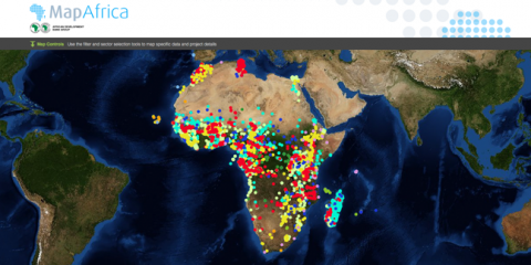
Today, the African Development Bank (AfDB) released MapAfrica – a dynamic online platform that will enable citizens, government officials, and donors to track investments from AfDB-funded development projects – at their 2014 Annual Meetings in Kigali, Rwanda. The MapAfrica effort builds upon AidData’s existing partnership with AfDB to geocode their ongoing projects, some dating back to 2002, up to 2013 (minus budget support and institutional strengthening in-vestments) by applying precise location information to discrete development activities. This geocoded data will be an important feature of the MapAfrica platform designed to help people visualize, at a glance, who is funding what and where and to see specific project results in the future.
Users of the MapAfrica platform will be able to filter projects by country, sector and year. For different perspectives on AfDB’s project portfolio, users can select individual country maps to view all projects within a country, or they can choose one project point on a map in order to see all other related locations for the project throughout the country. With these filtering options, policymakers and citizens can gain a better understanding of the scope of a project’s implementation and the distribution of resources for development by location. The platform design also includes various data layers to enable users to look at socio-economic and country specific indicators alongside activity implementation locations on the maps.
Realizing the full benefits of geocoding development finance data requires moving beyond a mapping exercise to thinking about the sustainability of these efforts over time. AfDB is working towards this as it partners with AidData to identify the best approaches in order to systematically integrate geocoding into AfDB’s internal processes. For example, AfDB will be incorporating geospatial fields – in line with updated International Aid Transparency Initiative standards – into its internal data-entry reporting processes. A geospatial widget to be developed with AidData will lower the burden of reporting on geospatial information alongside other project data.
AfDB’s commitment to institutionalizing geocoding into its long-term procedures marks a significant innovation consistent with the organization’s results-based approach. Creating this geocoding infrastructure and making the data publicly available are two important steps towards closing the feedback loop because they allow any citizen to view and assess the perceived impact of aid activities. This opens up an opportunity for a conversation between actors on the ground and the donors implementing and managing the projects and an opportunity for the AfDB to learn and improve the quality of its projects. Users could identify activities through location points on the map and directly contribute feedback through the platform. As AfDB plans to engage actively with local civil society in the future, MapAfrica could evolve into a vital communications channel that enables AfDB to capture feedback on its operations and incorporate this knowledge directly into their project cycle.
Watch the MapAfrica video to learn more and check back with us in the coming months to follow the ongoing development of the platform and AidData’s geocoding work with AfDB.
Rimal Kacem is an AidData Project Manager based at the Development Gateway office in Brussels, Belgium. Ellie Kaufman is a Communications Associate with AidData. This post was originally published on The AidData Blog: The First Tranche.
Share This Post
Related from our library
A Year After USAID: Reclaiming Control of Data Systems
Just months after the 2025 U.S. aid freeze was announced, we published a blog post warning that the USAID cuts would result in a data crisis, with some countries losing access to their digital health data. This blog explores how those systems – and the countries relying on them – have fared nearly a year on.

Introducing The HackCorruption Civic Tech Tools Repository
Introducing the Civic Tech Tools Repository: an open-source hub of digital solutions to fight corruption. Designed for growth through GitHub contributions, it brings together tools, code, and resources across six key areas for HackCorruption teams and beyond.

Building a Sustainable Cashew Sector in West Africa Through Data and Collaboration
Cashew-IN project came to an end in August 2024 after four years of working with government agencies, producers, traders, processors, and development partners in the five implementing countries to co-create an online tool aimed to inform, support, promote, and strengthen Africa’s cashew industry. This blog outlines some of the key project highlights, including some of the challenges we faced, lessons learned, success stories, and identified opportunities for a more competitive cashew sector in West Africa.