Mapping for the Fight Against HIV/AIDS in Côte d’Ivoire: Our Continued Adventure
Geography and accessibility to services hold significant weight in identifying comprehensive strategies to sustainably control the HIV/AIDS epidemic. The Open Geospatial Data Center for Health (OpenDCH) project, supported by PEPFAR, aims to advance analysis of where the most affected communities are located, to focus on closing gaps in HIV testing and treatment. It will serve to improve understanding of HIV program coverage at the community level — leading to improved adherence, retention, and targeting of services. The OpenDCH system will use OpenStreetMap (OSM) layers to take a more detailed approach to identifying high risk areas, ascertaining whether HIV/AIDS services are appropriately placed, and to improve health services accessibility.
Development Gateway (DG) and AidData have developed a strategy to map high-risk locations according to research by the Côte d’Ivoire Ministry of Health and USAID-Côte d’Ivoire. The seven focus locations include the cities of Soubré, San Pedro, and Bouaké; and four sections of Abidjan: Koumassi, Cocody II Plateaux, Abobo, and Yopougon.
What We Have Mapped So Far
In the past months, DG has been working with partners to develop and implement a strategy to use OSM to improve understanding of the HIV/AIDS epidemic in Côte d’Ivoire. In partnership with the Côte d’Ivoire Ministry of Health’s Direction de l’Informatique et de l’Information Sanitaire (Directorate for IT and Health Information – (DIIS), USAID-Côte d’Ivoire, and AidData, DG has completed 3 OSM mapathons (held in Washington, D.C., Williamsburg, VA, and Abidjan) and a comprehensive “training of trainers” event. An average of 30 participants have attended each mapathon, allowing DG and its partners to map all of San Pedro (east) and half of Soubré.
DG also conducted trainings and field mapping in Bouaké and San Pedro, in partnership with the Côte d’Ivoire mapping community, including OSM Côte d’Ivoire (OSMCI) and the Youth Mappers at Centre Universitaire de Recherche et d’Application en Télédétection (CURAT). Participants mapped thousands of points of interest (POIs) according to project objectives, including infrastructure, health facilities, schools, and less formal gathering spots. Despite the August rainy season and some logistical challenges, we’ve achieved 95% of mapping objectives in Bouaké and San Pedro.
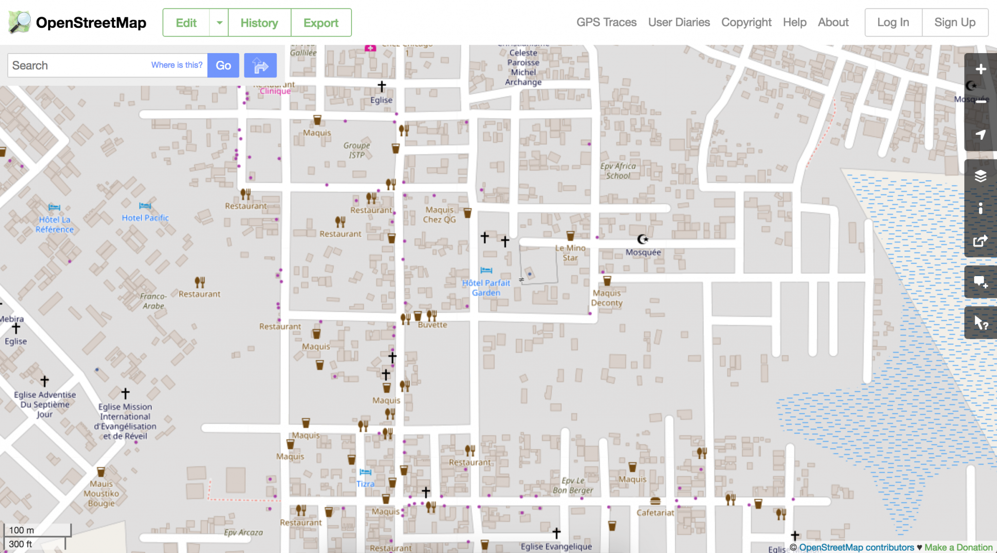
Figure 1: San Pedro field mapping results on OpenStreetMap
Mapping with a Gender Balance in Mind
Gender balance remains critical in selecting partners to participate in OpenStreetMap activities. DG and AidData’s high female participation rate stems from a vibrant, motivated OSM community of women in Côte d’Ivoire. Despite low representation in the wider OSM community (only 3% of Ivorian women participate in OSMCI), 34.78% of data collection participants in San Pedro and 23.80% in Bouaké were women. Both Mapathons also recorded high female participation rates (23.07% in Abidjan and 33.33% in Bouaké). These figures are due to women’s growing interest in engaging with OSM – an expanding network – as well as a better awareness of mapping’s professional, social, and personal impacts. Participants are eager to learn and improve, and each event fosters a community of shared experience and fruitful discussion lasting well past the duration of mapping itself. In addition, after data collection activities, two women were recognized for their excellent work and attention to detail.
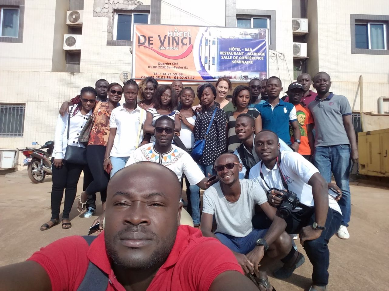
Figure 2: The DG, AidData, Youth Mappers, and OSMCI teams in San Pedro
Effective and continuous women’s participation in OSM is key to success in engaging more women in data collection. Through OpenDCH, DG and its partners are focused not only on technical tools, but also on the SDG imperative of Leaving No One Behind – by ensuring more and more citizens are engaged in data for decision making.
So What’s Next?
Data collection is currently underway in Soubré. Over the next five weeks, we will be mapping Yopougon, Cocody II Plateaux, Abobo and Koumassi. 15-20 people will be deployed over a period of 6 to 10 days in each location, depending on the area density.
How will OSM data be used through OpenDCH?
In the coming months, we will use OSM data as a layer to be superimposed with clinical geospatial data and disaggregated health indicators in the OpenDCH platform that is being developed by AidData. This OSM geospatial layer will allow us to better:
- Contribute to understanding of how the provision of health services affects HIV/AIDS transmission and response;
- Help reduce the duplication of mapping activities by a disparate set of stakeholder by creating a shared resource for improved knowledge-sharing and management;
- Enable analysis on geographic accessibility and coverage by combining data with additional data on infrastructure; and
- Enable policy makers and program implementers to target proximate causes and incidences of HIV by targeting hotspots and areas where at-risk populations are located.
Stay tuned for more updates on the DG blog on how we’re using OSM to build better foundations for gathering and analyzing health data, as we work to address HIV/AIDS in Côte d’Ivoire.
Share This Post
Related from our library

Introducing The HackCorruption Civic Tech Tools Repository
Introducing the Civic Tech Tools Repository: an open-source hub of digital solutions to fight corruption. Designed for growth through GitHub contributions, it brings together tools, code, and resources across six key areas for HackCorruption teams and beyond.

From Standardization to Specificity: Localizing Multi-Country Research
Multi-country research must balance consistency with local realities. While standardization allows reliable comparisons and generalizable insights, local context shapes outcomes. This blog explores how programs can strike that balance effectively.

Economic Toll of Tobacco-Related Diseases in Kenya: New Research Findings
Development Gateway: An IREX Venture (DG) is pleased to announce the publication of a research manuscript on the Economic Costs of Tobacco-Related Illnesses in Kenya. This research was carried out as part of the Tobacco Control Data Initiative (TCDI) activities in Kenya and is part of a broader report on Morbidity and Mortality from Tobacco Use in Kenya.