Philippines Launch Open GIS Portal
Today, the Philippine National Economic and Development Agency (NEDA) launched its new GIS portal for development assistance and public investment projects. This portal represents an important step in continuing the Government’s commitment to fiscal transparency, with all data available for download in open formats.
As part of the AidData Center for Development Policy (ACDP), Development Gateway (DG) began collaborating with NEDA and USAID/Philippines to collect detailed sub-national data on all development assistance projects, create an interactive web portal to help NEDA and its partners analyze and use these data, and develop data management plans for ongoing data collection and maintenance. To support these efforts, DG embedded an Aid Management Fellow within NEDA for 8 months.
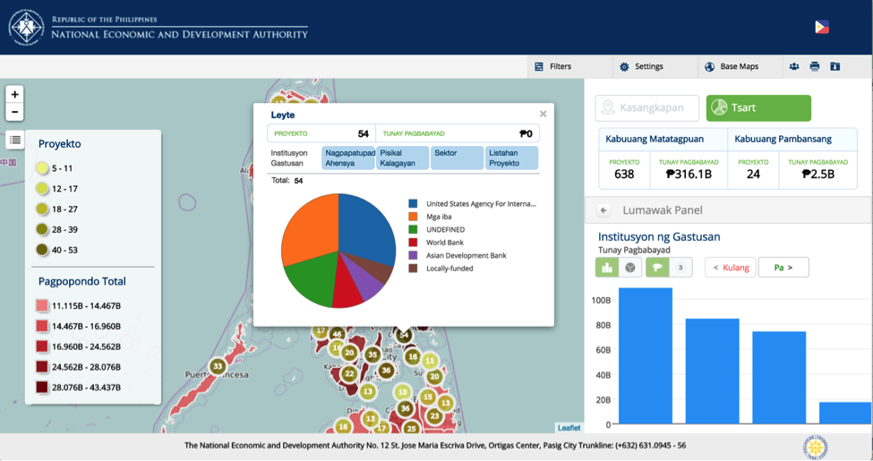
Figure 1: NEDA Portal Map and Dashboards
Available in both English and Filipino, the portal includes details on nearly 500 development assistance projects worth PHP316.1 billion (USD $6.5 billion) and 150 government budget-funded projects with PHP112.1 billion in actual expenditures (USD $2.3 billion) at the regional, provincial, or municipal level. The inclusion of detailed locations on government budget programs is particularly noteworthy, representing a strong achievement against the Philippines OGP National Action Plan commitment on “sustain[ing] transparency in local government plans and budget.”
At the very local level, nearly 2,000 geo-tagged photos can be visualized showing implementation progress at exact project sites. Future plans include working with Regional NEDA offices and other government departments and development partners to increase the number of geotagged photos, providing unprecedented transparency of service delivery.
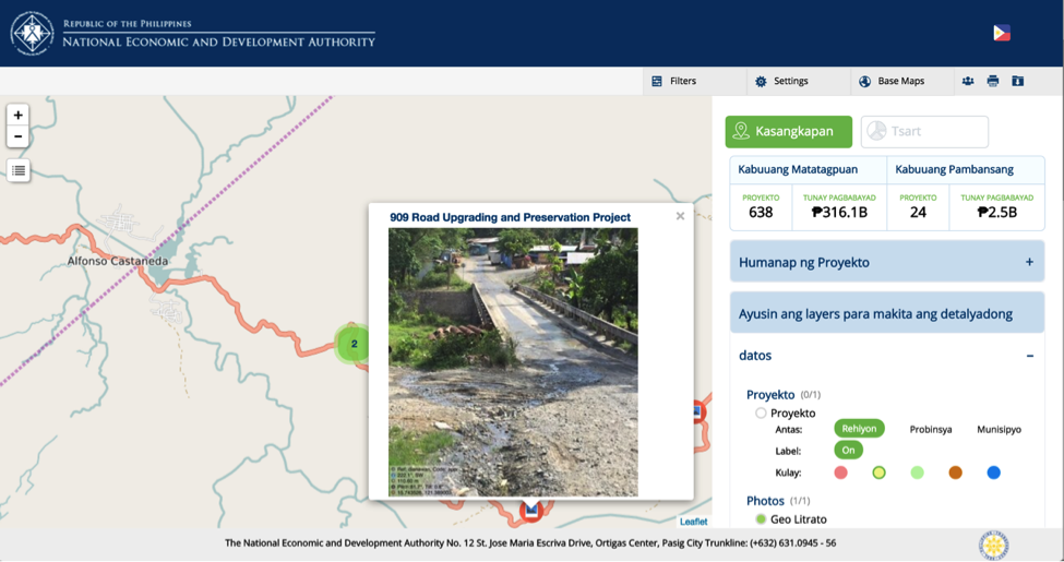
Figure 2: NEDA Portal Geo-tagged Photos
Within NEDA, the GIS platform will be used to facilitate monitoring of projects, coordination of development partners, and prioritization of investments to less-served areas. An “executive dashboard” functionality will allow NEDA leadership to have pre-made maps ready for their inspection, allowing for more informed planning and project design with the Philippines’ development partners. Moving forward, we will share stories of how these tools and data are used are used, and on the technical details of the platform.
Image: Adam Cohn CC BY-NC-ND 2.0
Share This Post
Related from our library

Introducing The HackCorruption Civic Tech Tools Repository
Introducing the Civic Tech Tools Repository: an open-source hub of digital solutions to fight corruption. Designed for growth through GitHub contributions, it brings together tools, code, and resources across six key areas for HackCorruption teams and beyond.

Building a Sustainable Cashew Sector in West Africa Through Data and Collaboration
Cashew-IN project came to an end in August 2024 after four years of working with government agencies, producers, traders, processors, and development partners in the five implementing countries to co-create an online tool aimed to inform, support, promote, and strengthen Africa’s cashew industry. This blog outlines some of the key project highlights, including some of the challenges we faced, lessons learned, success stories, and identified opportunities for a more competitive cashew sector in West Africa.
Digital Transformation for Public Value: Development Gateway’s Insights from Agriculture & Open Contracting
In today’s fast-evolving world, governments and public organizations are under more pressure than ever before to deliver efficient, transparent services that align with public expectations. In this blog, we delve into the key concepts behind digital transformation and how it can enhance public value by promoting transparency, informing policy, and supporting evidence-based decision-making.